Bermuda Triangle
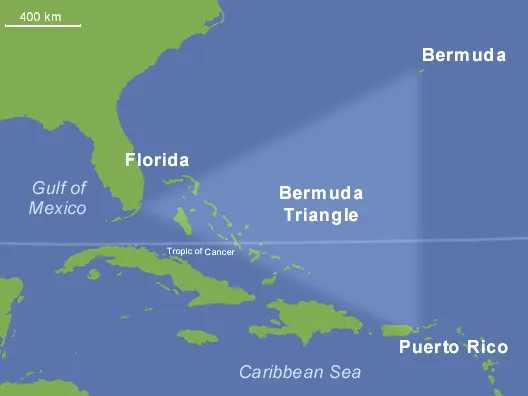
The Bermuda Triangle (also known as the "Devil's Triangle") is a loosely defined oceanic region in the western North Atlantic, conventionally demarcated by points connecting the Bermuda archipelago, Miami (Florida), and San Juan (Puerto Rico). Encompassing an area of roughly 1 to 1.5 million square kilometers, the sector encompasses the Florida Straits, the Bahamas, and portions of the Sargasso Sea. Throughout the latter half of the 20th century, the zone became the premier global archetype of maritime and aviation lore, reputed across popular culture for the unexplainable disappearance of dozens of vessels and aircraft.
The legend
Danger Level: Yellow (Authentic open-ocean meteorological and navigation hazards sensationalized by popular media into a supernatural death trap) The mythology of the Bermuda Triangle contends that a malevolent, unseen force operates across the sector, erasing maritime and aerial traffic without leaving wreckage. According to lore, navigators regularly suffered catastrophic communication blackouts, magnetic compasses spun wildly attempting to align with true rather than magnetic north, and aircraft dissolved off radar screens without broadcasting distress calls. Sensationalist publications attributed these incidents to space-time rifts, underwater alien bases, and the residual energy crystals of sunken Atlantis operating on the ocean floor. The foundational pillars of the myth were the disappearance of the US Navy collier USS Cyclops with 306 crewmen aboard in March 1918 and the loss of five US Navy TBM Avenger torpedo bombers ("Flight 19") alongside a PBM Mariner rescue flying boat on December 5, 1945.
What actually happened?
The mystery was comprehensively dismantled by Arizona State University research librarian Lawrence David Kusche in his 1975 investigative work The Bermuda Triangle Mystery — Solved. Kusche audited original naval inquiry boards, US Coast Guard distress logs, weather archives, and the maritime insurance records of Lloyd's of London: Statistical normalcy: Official statistics compiled by Lloyd's of London and the US Coast Guard confirm that the rate of vessel and aircraft casualties across the Bermuda Triangle is not statistically higher than in any other high-density maritime transit corridor on Earth. Thousands of cargo ships, commercial airliners, and passenger cruise liners navigate the sector continuously without incident. Maritime insurers have never levied elevated premiums for voyages transiting the zone. Literary distortions and fabrication: Proponents of the myth (principally Charles Berlitz) regularly distorted operational facts. Incidents taking place thousands of miles away—in the Pacific Ocean, near Ireland, or inside the Gulf of Mexico—were retroactively claimed as Triangle casualties. Authors routinely claimed vessels vanished in "calm seas," whereas official meteorological logs verified gale-force hurricanes and 50-foot rogue seas. In several cases, vessels reported as "mysteriously lost" actually completed their voyages and berthed safely. Oceanographic realities: The region is bisected by the high-velocity Gulf Stream current, flowing at up to 5 knots, which scatters wreckage, flotation gear, and slick lines within hours. The area experiences sudden squalls, waterspouts, and severe tropical depressions. Furthermore, the southern boundary encompasses the Puerto Rico Trench, descending to depths of 8,376 meters, making the location and recovery of sunken hulls technically prohibitive. The loss of Flight 19: The official US Navy board of inquiry established a clear sequence of spatial disorientation and pilot error. Flight leader Lieutenant Charles Taylor suffered compass failures and mistakenly believed he had drifted over the Florida Keys. Rejecting trainee input, he steered east and northeast into the open, unlit Atlantic under deteriorating storm conditions until the aircraft exhausted their fuel reserves. The searching PBM-5 Mariner flying boat suffered an in-flight fuel vapor explosion, an eyewitness event corroborated by officers aboard the commercial tanker SS Gaines Mills. Methane hydrate hypothesis: The fringe theory proposing that subsea methane hydrate blowouts abruptly lower water density to sink hulls was refuted by oceanographic surveys: the seafloor sediments across the Triangle lack the geological conditions required to generate massive explosive gaseous eruptions during the Holocene epoch.
History
Early press coverage began circulating in the late 1940s following the loss of Flight 19. The specific moniker "The Bermuda Triangle" was coined by writer Vincent Gaddis in the February 1964 issue of the pulp magazine Argosy in an article titled "The Deadly Bermuda Triangle." International mania erupted in 1974 with the publication of Charles Berlitz's runaway bestseller The Bermuda Triangle, which sold over 20 million copies and spurred a multi-decade wave of sensationalized television documentaries and occult paperbacks. The publication of Lawrence Kusche's definitive refutation in 1975 systematically dismantled the claims. By the early 2000s, the advent of global satellite tracking, GPS navigation, ship-borne AIS beacons, and real-time orbital meteorology resolved open ocean search-and-rescue ambiguities, cementing the Triangle as a mid-century cultural artifact.
Where is it?
North Atlantic Ocean; an imaginary triangular oceanic quadrant delimited by the southeastern coast of the United States (Miami, Florida), the British Overseas Territory of Bermuda, and the Caribbean island of Puerto Rico (San Juan).
Can you visit?
Yes, the Bermuda Triangle is fully accessible and constitutes one of the most heavily traversed maritime and aviation corridors on the globe. Daily transit across the zone is maintained by international airlines, freight liners, and commercial cruise vessels connecting North America to the Caribbean and South America. Navigation across the sector is routine and unrestricted. Ocean-going voyagers simply adhere to standard open-sea maritime protocols: monitoring seasonal hurricane forecasts (June through November) and maintaining operational satellite communications and marine radar arrays.
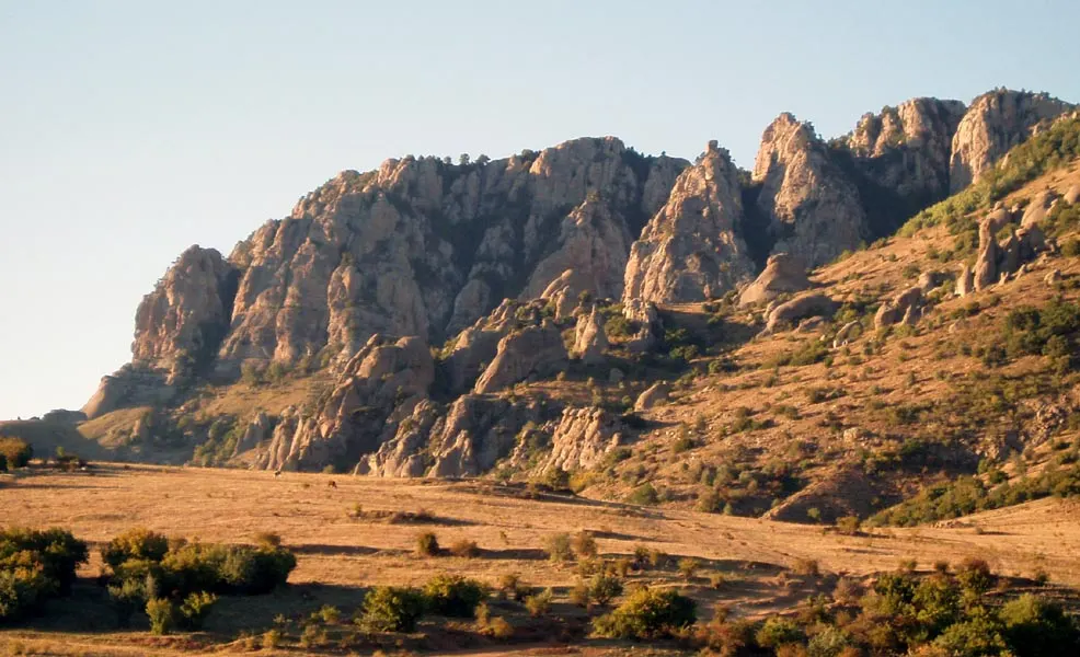
The Valley of Ghosts on Demerdzhi
A slope of the Crimean mountain Demerdzhi scattered with hundreds of stone pillars up to twenty-five metres high — conglomerate from which the rain has washed the softer rock. In mist and at sunset the shapes read as people and animals, and the outlines shift with the light. A Crimean Tatar tradition explains them by the curse of a blacksmith who settled on the mountain; the name means blacksmith. In 1966 the mountain slid and buried part of the village of Lavanda.