Plymouth
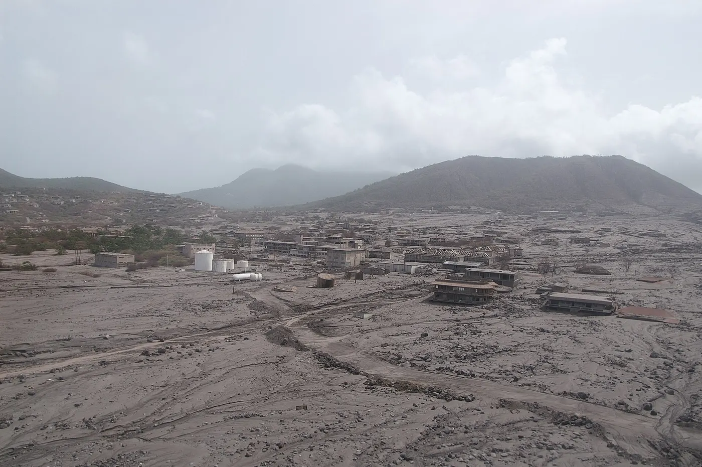
Plymouth is an abandoned ghost city situated along the southwestern coast of the island of Montserrat, a British Overseas Territory in the Leeward Islands of the Caribbean Sea. Historically the island's capital, primary commercial center, and port, the municipality was systematically destroyed and buried beneath meters of volcanic ash, pumice, and catastrophic lahars during the 1995–1997 eruptions of the Soufrière Hills stratovolcano. Plymouth holds a unique global geopolitical status: it remains the world's only de jure official capital that is completely uninhabited de facto, earning the international designation of "the Pompeii of the Caribbean."
The legend
Danger Level: Red (An active stratovolcano footprint subject to explosive dome collapses, toxic sulfur dioxide venting, pyroclastic surges, and flash lahars within an Exclusion Zone) The rapid obliteration of the Caribbean colonial capital generated modern folklore and political conspiracy narratives: The Carib Shaman Curse: Regional oral folklore attributed the awakening of the long-dormant volcano to an indigenous ancestral curse, alleging that late-20th-century geothermal drilling and luxury estate development desecrated the sacred burial grounds of the pre-Columbian Carib and Arawak populations; The Phantom Bell of St. Anthony: Maritime folklore and fringe travel accounts claimed that the bronze bell of the 17th-century St. Anthony’s Anglican Church—whose rooftop and clock tower barely peek through meters of hardened volcanic sludge—tolls spontaneously on stormy nights, while spectral apparitions of colonial planters wander the half-buried upper balconies; The Imperial Depopulation Plot: Following the 1997 disaster, local political rumors alleged that the British Government and scientific advisers exaggerated risk parameters to engineer a forced evacuation of the island's populace, thereby relieving the Crown of costly post-colonial infrastructure subsidies.
What actually happened?
The destruction of Plymouth represents a documented geological disaster within a subduction arc, continuously monitored by the Montserrat Volcano Observatory (MVO) and the British Geological Survey (BGS):Geological mechanism: The Soufrière Hills stratovolcano is driven by the westward subduction of the North American Plate beneath the Caribbean Plate. Dormant since approximately 1630, the system reawakened on July 18, 1995, with phreatic explosions caused by the ascension of andesitic magma. An extrusion of a massive lava dome destabilized under gravity at the summit, resulting in episodic structural failures.The 1997 pyroclastic surges: Destruction occurred in successive phases. On June 25, 1997, a catastrophic dome collapse unleashed pyroclastic density currents—avalanches of superheated gas, pumice, and pulverized rock traveling in excess of 150 km/h at temperatures exceeding 400–700 °C. Nineteen people were killed on agricultural plots in the exclusion perimeter. In August 1997, secondary pyroclastic surges swept directly through downtown Plymouth, incinerating government compounds, melting civil infrastructure, and extending the coastline into the ocean.Lahar sedimentation: Following the fiery surges, heavy tropical rainfall triggered recurrent lahars (volcanic mudflows). Volcanic debris washed down the Belham and Fort Ghaut river valleys, depositing between 3 and 12 meters of sediment over Plymouth. Commercial banks, churches, and civic plazas were entombed up to their upper stories and rooflines.Demographic exodus: Systematic phased evacuations launched by civil defense in August 1995 and finalized by April 1996 prevented mass casualties inside the municipal borders. However, the disaster cut the island's demographics: of the pre-eruption population of roughly 13,000, over 8,000 residents relocated permanently to the United Kingdom, Antigua, and broader Commonwealth nations.Atmospheric hazards: The ruins remain environmentally hazardous. Atmospheric readings document periodic surges of sulfur dioxide ($SO_2$) and hydrogen sulfide ($H_2S$). The fine airborne ash contains cristobalite (a crystalline silica polymorph), which poses severe silicosis and pulmonary hazards upon inhalation.
History
Plymouth was established in 1632 by Irish Catholic settlers fleeing religious discrimination on neighboring Saint Kitts, named after the Devon port of Plymouth in England. Throughout the 17th to 19th centuries, it grew into an administrative center for regional sugarcane plantations and slave markets, protected by coastal bastions like Fort George. During the late 20th century, the island became famous in the recording industry: legendary Beatles producer Sir George Martin established AIR Studios Montserrat, where iconic rock albums were recorded by artists including Dire Straits, The Police, Paul McCartney, Black Sabbath, and The Rolling Stones. In September 1989, Category 5 Hurricane Hugo devastated 90% of Plymouth’s structures. The 1995 volcanic cycle sealed the settlement's fate. By December 1997, the municipality was abandoned. Administrative functions relocated to the northern safe sector at the village of Brades, with long-term infrastructure concentrated at Little Bay.
Where is it?
Saint Anthony Parish, Montserrat, British Overseas Territory, Leeward Islands; situated along the southwestern coastal shelf at the mouth of Fort Ghaut, directly beneath the western flank of the Soufrière Hills volcano.
Can you visit?
Plymouth lies within Zone V of the official Montserrat Exclusion Zone. Civilian access is governed by the Royal Montserrat Police Service and the Montserrat Volcano Observatory: Overland access: Independent unguided entry is illegal, carrying immediate arrest, fines, and deportation. Overland vehicle entry is permitted strictly via authorized, police-vetted tour operators when the regional volcanic alert remains stabilized at Hazard Level 1. Guides carry two-way VHF communication radios tied directly to the MVO operations room to receive evacuation orders. Maritime observation: The safest viewing method involves commercial boat charters and catamarans navigating offshore outside the thermal marine exclusion boundary. Safety guidelines: Visitors touring the ruins must wear particulate respirators and durable closed-toe hiking footwear. Entering buried buildings is strictly barred due to severe roof-load collapses, structural decay, and unstable mud cavities. The zone is closed immediately upon any seismic or gas emission spike.
Oradour-sur-Glane
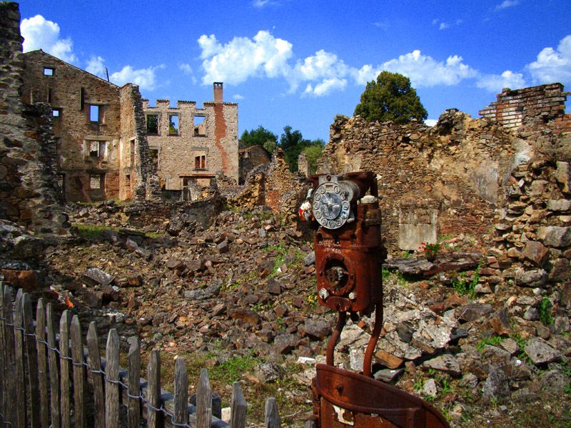
Oradour-sur-Glane is a preserved ghost village and national memorial located in the Haute-Vienne department of Nouvelle-Aquitaine, France, situated along the Glane River roughly 22 kilometers northwest of Limoges. On June 10, 1944, the tranquil rural community was systematically liquidated by the 2nd SS Panzer Division Das Reich, who massacred 643 civilians (including 247 women and 205 children) before putting every structure to the torch. Following the liberation, French Provisional Government President Charles de Gaulle decreed that the skeletal ruins remain entirely untouched as an open-air national shrine and enduring monument to Nazi wartime atrocities against civilian populations.
Comments
No comments yet. Be the first.